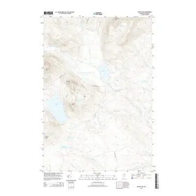
2014 Map of Silver Lake
USGS Topo · Published 2014About this map
Silver Lake and the West Branch Pleasant River anchor this topographic view of the Maine woods, revealing a landscape defined by industrial access and natural water systems. The network of unimproved roads, including Ore Mountain Rd and Dexter Mills Rd, provides access to the high peaks of Chairback Mtn and Saddleback Mtn. The terrain is deeply carved by numerous drainages such as Big White Brook and Houston Brook, which feed into major water bodies like Big Houston Pond and Sucker Brook Pond. The presence of Ore Mtn and its associated roadway suggests a history of resource extraction or land management in this remote Piscataquis County region, while the various "Pond" and "Brook" designations reflect the classic hydrography of the Northern Maine wilderness.
Find a feature on this map
28 named features on this map. Tap any name to fly to it.
Don’t see what you’re looking for? This feature index may not catch every label — zoom into the map to look around manually.
Map Details
Editions of this 2014 Silver Lake Map
This is the sole edition of this map. No revisions or reprints were ever made.
Other maps of this area

1940 · Sebec
USGS Topo · 1:48,000

1943 · Sebec
USGS Topo · 1:62,500

1950 · Sebec Lake
USGS Topo · 1:62,500

1952 · Jo-Mary Mountain
USGS Topo · 1:62,500

1952 · First Roach Pond
USGS Topo · 1:62,500

1954 · Millinocket
USGS Topo · 1:250,000

1958 · Millinocket
USGS Topo · 1:250,000

1960 · Millinocket
USGS Topo · 1:250,000
1978 · Hay Mountain
USGS Topo · 1:24,000
1978 · Silver Lake
USGS Topo · 1:24,000
Featured Places
- Bowerbank, ME
- Barnard Township, ME
- Williamsburg Township, ME
- Bowdoin College Grant East Township, ME
- TB R11 WELS, ME