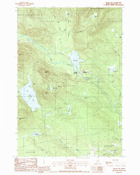
1988 Map of Silver Lake
USGS Topo · Published 1988About this map
Katahdin Iron Works anchors this mid-1980s landscape at the confluence of the West Branch Pleasant River and Silver Lake. The map details a transition from industrial heritage to wilderness recreation, centered on the Katahdin Iron Works State Park. The surrounding terrain is defined by significant elevations like Saddleback Mountain and Ore Mountain, the latter hinting at the raw materials that once fueled the local economy. Toward the north and west, the map delineates vast educational and timber holdings, including the Bowdoin College Grant East. Remote seasonal outposts such as Pine Camp and Arnold Camps are scattered near water bodies like Houston Pond, illustrating the area's late 20th-century character as a hub for forestry and backcountry sporting life.
Find a feature on this map
33 named features on this map. Tap any name to fly to it.
Don’t see what you’re looking for? This feature index may not catch every label — zoom into the map to look around manually.
Map Details
Editions of this 1988 Silver Lake Map
This is the sole edition of this map. No revisions or reprints were ever made.
Other maps of this area

1940 · Sebec
USGS Topo · 1:48,000

1943 · Sebec
USGS Topo · 1:62,500

1950 · Sebec Lake
USGS Topo · 1:62,500

1952 · Jo-Mary Mountain
USGS Topo · 1:62,500

1952 · First Roach Pond
USGS Topo · 1:62,500

1954 · Millinocket
USGS Topo · 1:250,000

1958 · Millinocket
USGS Topo · 1:250,000

1960 · Millinocket
USGS Topo · 1:250,000
1978 · Hay Mountain
USGS Topo · 1:24,000
1978 · Silver Lake
USGS Topo · 1:24,000
Featured Places
- Bowerbank, ME
- Katahdin Iron Works Township, ME
- Williamsburg Township, ME
- T7 R9 NWP, ME
- Barnard Township, ME