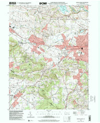
1999 Map of Sinking Spring
USGS Topo · Published 2001About this map
The sprawling campus of the Wernersville State Hospital and the nearby Novitiate of St Isaac Jogues dominate the lower slopes of the South Mountain ridge during the turn of the millennium. This landscape in western Berks County exhibits a complex mix of mid-century institutional sites and rapidly expanding residential developments like Springmont and Colonial Hills. The northern section is defined by the massive Blue Marsh Lake on the Tulpehocken Creek, while the southern reaches cross into Lancaster County near Reinholds and Adamstown.
Find a feature on this map
64 named features on this map. Tap any name to fly to it.
Don’t see what you’re looking for? This feature index may not catch every label — zoom into the map to look around manually.
Map Details
Editions of this 1999 Sinking Spring Map
This is the sole edition of this map. No revisions or reprints were ever made.
Other maps of this area

1894 · Reading
USGS Topo · 1:62,500

1902 · Wernersville
USGS Topo · 1:62,500

1905 · Honey Brook
USGS Topo · 1:62,500

1906 · New Holland
USGS Topo · 1:62,500

1907 · Honeybrook
USGS Topo · 1:62,500

1908 · New Holland
USGS Topo · 1:62,500

1913 · Reading
USGS Topo · 1:62,500

1915 · Reading
USGS Topo · 1:62,500

1941 · Honeybrook
USGS Topo · 1:62,500

1941 · New Holland
USGS Topo · 1:62,500
Featured Places
- Sinking Spring, PA
- Wernersville, PA
- Reinholds, West Cocalico Township
- North Heidelberg Township, PA
- West Cocalico Township, PA