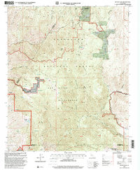
1997 Map of Sitton Peak
USGS Topo · Published 2000About this map
Potrero De La Cienega Land Grant and Potrero El Cariso Land Grant define the complex land tenure of this corner of the Santa Ana Mountains during the late 1990s. The landscape is dominated by the Cleveland National Forest and the protected San Mateo Canyon Wilderness, where narrow drainages like Tenana Canyon and Lucas Canyon carve through steep terrain. Human presence is marked by the remote Stewart Ranch and high points such as Sitton Peak, accessible via the Ortega Highway.
Find a feature on this map
72 named features on this map. Tap any name to fly to it.
Don’t see what you’re looking for? This feature index may not catch every label — zoom into the map to look around manually.
Map Details
Editions of this 1997 Sitton Peak Map
This is the sole edition of this map. No revisions or reprints were ever made.
Other maps of this area

1901 · Southern California Sheet No. 1
USGS Topo · 1:250,000

1901 · Elsinore
USGS Topo · 1:125,000

1901 · San Luis Rey
USGS Topo · 1:125,000

1902 · Capistrano
USGS Topo · 1:125,000

1902 · Corona
USGS Topo · 1:125,000

1904 · Southern California Sheet No. 2
USGS Topo · 1:250,000

1904 · Southern California Sheet No. 1
USGS Topo · 1:250,000

1906 · Capistrano
USGS Topo · 1:125,000

1941 · Margarita Peak
USGS Topo · 1:62,500

1942 · Lake Elsinore
USGS Topo · 1:62,500
Featured Places
- Marine Corps Base Camp Pendleton, CA
- San Diego County, CA
- Orange County, CA
- Riverside County, CA
- United States