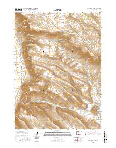
2017 Map of Skull Creek Butte
USGS Topo · Published 2017About this map
Catlow Rim forms a dramatic topographical boundary in this part of Harney County, separating the high desert plateau from the expansive Catlow Valley to the west. This 2017 survey details a landscape defined by seasonal water sources and distinct landforms, including the prominent Skull Creek Butte rising near the Skull Cr Reservoir. The map illustrates the specialized infrastructure of high-desert ranching and travel, from the engineered Echart Grade to vital watering points like Bohemian Spring and O'Keefe Springs. Deep canyons and drainages, such as Coon Canyon and Road Canyon, carve through the basin and range geology. This digital-era update by the U.S. Geological Survey traces the modern path of the Catlow Valley Rd, providing an essential view of the drainage systems of Sixmile Cr and Skull Cr as they influence the local environment.
Find a feature on this map
25 named features on this map. Tap any name to fly to it.
Don’t see what you’re looking for? This feature index may not catch every label — zoom into the map to look around manually.
Map Details
Editions of this 2017 Skull Creek Butte Map
This is the sole edition of this map. No revisions or reprints were ever made.
Other maps of this area

1955 · Adel
USGS Topo · 1:250,000

1957 · Adel
USGS Topo · 1:250,000

1958 · Adel
USGS Topo · 1:250,000

1962 · Adel
USGS Topo · 1:250,000

1968 · Roaring Springs SE
USGS Topo · 1:24,000

1968 · Ankle Creek
USGS Topo · 1:24,000

1971 · Square Mountain
USGS Topo · 1:24,000

1971 · Fields Basin
USGS Topo · 1:24,000

1971 · Garrison Lake
USGS Topo · 1:24,000

1971 · V Lake
USGS Topo · 1:24,000