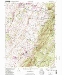
1994 Map of Smithsburg
USGS Topo · Published 1999About this map
South Mountain dominates this landscape, where the historic Mason and Dixon Line marks the border between Maryland and Pennsylvania. This 1990s update, based on mid-century topographic foundations, captures the region's dense mix of mountain terrain and agricultural valley settlements. To the north, Waynesboro and Wayne Heights show established residential growth, while the heights are defined by the Ritchie Military Reservation and landmarks like Quirauk Mtn. The valley floor near Smithsburg and Leitersburg is dotted with local heritage sites, including Weltys Ch and Stouffers Cem, reflecting a long history of rural community life. Significant water infrastructure is present through the Hagerstown Reservoir and Edgemont Reservoir, which sit at the foot of the ridge near Raven Rock. Small enclaves like Buena Vista Springs and Pen Mar emphasize the area's legacy as a highland retreat.
Find a feature on this map
50 named features on this map. Tap any name to fly to it.
Don’t see what you’re looking for? This feature index may not catch every label — zoom into the map to look around manually.
Map Details
Editions of this 1994 Smithsburg Map
This is the sole edition of this map. No revisions or reprints were ever made.
Other maps of this area

1902 · Chambersburg
USGS Topo · 1:62,500

1909 · Fairfield
USGS Topo · 1:62,500

1909 · Hagerstown
USGS Topo · 1:48,000

1911 · Emmitsburg
USGS Topo · 1:62,500

1912 · Hagerstown
USGS Topo · 1:62,500

1942 · Hagerstown
USGS Topo · 1:125,000

1942 · Gettysburg
USGS Topo · 1:125,000

1943 · Emmitsburg
USGS Topo · 1:62,500

1943 · Hagerstown
USGS Topo · 1:125,000

1943 · Chambersburg
USGS Topo · 1:62,500
Featured Places
- Waynesboro, PA
- Smithsburg, MD
- Wayne Heights, Washington Township
- Cavetown, MD
- Pen Mar, Washington Township