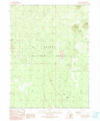
1990 Map of Snag Hill
USGS Topo · Published 1990About this map
Shasta National Forest defines the rugged geography of this high-elevation landscape, where the volcanic character of the terrain is evident in features like Lava Crack Spring and the subterranean formations of Ice River Caves and Water Caves. The map documents a sparse but significant industrial presence, primarily related to timber and water access in the late 20th century. Traces of historical transportation are visible through the Old RR Grade and the Chippy Spur, indicating the area's role in the regional logging economy. Isolated landmarks like Lost Iron Well and the prominent heights of Snag Hill and Powder Hill provide essential points of orientation within this dense wilderness. The arrangement of these features suggests a landscape managed for resource extraction while remaining largely dominated by its natural geological curiosities.
Find a feature on this map
13 named features on this map. Tap any name to fly to it.
Don’t see what you’re looking for? This feature index may not catch every label — zoom into the map to look around manually.
Map Details
Editions of this 1990 Snag Hill Map
This is the sole edition of this map. No revisions or reprints were ever made.
Other maps of this area

1886 · Modoc Lava Bed
USGS Topo · 1:250,000

1892 · Modoc Lava-Bed
USGS Topo · 1:250,000

1932 · Bartle
USGS Topo · 1:96,000

1939 · Bartle
USGS Topo · 1:125,000

1950 · Bray
USGS Topo · 1:62,500

1952 · Medicine Lake
USGS Topo · 1:62,500

1954 · Alturas
USGS Topo · 1:250,000

1958 · Alturas
USGS Topo · 1:250,000

1961 · Hambone
USGS Topo · 1:62,500

1961 · Bartle
USGS Topo · 1:62,500