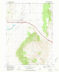
1968 Map of Snowville
USGS Topo · Published 1980About this map
Snowville sits at a critical high-desert junction in northern Utah, where the Curlew Valley meets the rising slopes of the North Hansel Mountains. This 1968 field-checked survey captures the community as a vital stop for travelers, marked by the construction of Interstate 80n alongside the older 30s highway. For genealogists and local historians, the Snowville Cem and various family-scale agricultural landmarks like the Rose Ranch Reservoir provide a detailed look at the rural footprint of the era.
Find a feature on this map
23 named features on this map. Tap any name to fly to it.
Don’t see what you’re looking for? This feature index may not catch every label — zoom into the map to look around manually.
Map Details
Editions of this 1968 Snowville Map
2 editions found
Other maps of this area

1954 · Pocatello
USGS Topo · 1:250,000

1954 · Brigham City
USGS Topo · 1:250,000

1958 · Pocatello
USGS Topo · 1:250,000

1958 · Brigham City
USGS Topo · 1:250,000

1962 · Brigham City
USGS Topo · 1:250,000

1968 · Salt Wells
USGS Topo · 1:24,000

1968 · Rattlesnake Pass
USGS Topo · 1:24,000

1968 · Snowville
USGS Topo · 1:24,000
1968 · Bulls Pass
USGS Topo · 1:24,000

1968 · Monument Peak
USGS Topo · 1:24,000