
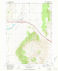
1968 Map of Snowville
USGS Topo · Published 1972About this map
Snowville stands at the northern edge of the Curlew Valley, serving as a vital crossroads near the Idaho-Utah state line. This late-1960s survey documents a period of significant infrastructure development, most notably the highway improvements designated as 2 lane under construction passing through the town. The landscape transitions from the flat, agricultural expanse of the valley floor to the steep elevations of the Hansel Mountains and the sheltered depths of Big Canyon.
Find a feature on this map
21 named features on this map. Tap any name to fly to it.
Don’t see what you’re looking for? This feature index may not catch every label — zoom into the map to look around manually.
Map Details
Editions of this 1968 Snowville Map
2 editions found
Other maps of this area

1954 · Pocatello
USGS Topo · 1:250,000

1954 · Brigham City
USGS Topo · 1:250,000

1958 · Pocatello
USGS Topo · 1:250,000

1958 · Brigham City
USGS Topo · 1:250,000

1962 · Brigham City
USGS Topo · 1:250,000

1968 · Salt Wells
USGS Topo · 1:24,000

1968 · Rattlesnake Pass
USGS Topo · 1:24,000
1968 · Bulls Pass
USGS Topo · 1:24,000

1968 · Monument Peak
USGS Topo · 1:24,000

1968 · Monument Peak NE
USGS Topo · 1:24,000