
1958 Map of Brigham City
USGS Topo · Published 1958About this map
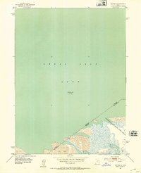
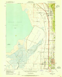
Brigham City and the fertile Bear River Valley serve as the eastern anchor for this mid-century portrait of northern Utah, where agricultural productivity meets expansive military and environmental reserves. The industrial footprint of the region is evident at the Brigham Sugar Mill, while the social fabric of rural life is marked by the Booth Valley School and the Latter Day Saints Church Farm. To the west, the landscape shifts dramatically into the Great Salt Lake and the Great Salt Lake Desert, a region defined by its isolation and strategic utility.
Find a feature on this map
100 named features on this map. Tap any name to fly to it.
Don’t see what you’re looking for? This feature index may not catch every label — zoom into the map to look around manually.
Map Details
Editions of this 1958 Brigham City Map
This is the sole edition of this map. No revisions or reprints were ever made.
Other maps of this area

1885 · Salt Lake
USGS Topo · 1:250,000

1885 · Tooele Valley
USGS Topo · 1:250,000

1914 · Logan
USGS Topo · 1:125,000

1915 · Preston
USGS Topo · 1:96,000

1916 · Logan
USGS Topo · 1:125,000

1918 · Preston
USGS Topo · 1:125,000

1925 · Ft. Douglas
USGS Topo · 1:125,000

1928 · Ft. Douglas
USGS Topo · 1:125,000
1952 · Saltair NE
USGS Topo · 1:24,000
1952 · Farmington
USGS Topo · 1:24,000