
1952 Map of Saltair NE
USGS Topo · Published 1953About this map
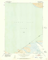
The expansive Great Salt Lake dominates this mid-century survey, shown at an elevation of 4200 feet as recorded in the early 1950s. This specific quadrant highlights the desolate interface between the water and the surrounding Salt Flat, a landscape defined by shifting shorelines and industrial utility. Along the southeastern edge, the Salt Lake City Sewage Canal cuts through the marshy terrain, protected in part by a constructed Levee. The map documents the Davis and Salt Lake county boundary as it strikes across the open water and mineral crusts. This edition reflects the environment before major modern infrastructure altered the eastern shore, providing a clear record of the natural and early man-made features that shaped the approach to the lake during this era.
Find a feature on this map
7 named features on this map. Tap any name to fly to it.
Don’t see what you’re looking for? This feature index may not catch every label — zoom into the map to look around manually.
Map Details
Editions of this 1952 Saltair NE Map
2 editions found
Other maps of this area

1885 · Salt Lake
USGS Topo · 1:250,000

1885 · Tooele Valley
USGS Topo · 1:250,000

1925 · Ft. Douglas
USGS Topo · 1:125,000

1928 · Ft. Douglas
USGS Topo · 1:125,000

1951 · Saltair
USGS Topo · 1:24,000

1951 · Salt Lake City North
USGS Topo · 1:24,000

1952 · Farmington
USGS Topo · 1:24,000

1952 · Antelope Island South
USGS Topo · 1:24,000

1953 · Tooele
USGS Topo · 1:250,000

1954 · Antelope Island
USGS Topo · 1:24,000