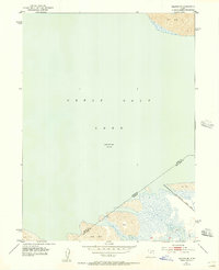
1952 Map of Saltair NE
USGS Topo · Published 1957About this map
The Great Salt Lake dominates this mid-century survey, capturing a specific moment in the fluctuating water levels of the eastern basin. Recorded at an elevation of 4,200 feet in 1951, the shoreline reveals a vast transition between the open water and extensive salt flats. This particular reach of the lake margin highlights the infrastructure of the era, including a levee and the Salt Lake City Sewage Canal cutting through the marshy lowland near the metropolitan periphery. The map also delineates the Davis and Salt Lake county line, providing a precise reference for those researching land ownership or jurisdictional boundaries along the lake's southeastern edge before significant modern development altered the drainage and coastal profile.
Find a feature on this map
7 named features on this map. Tap any name to fly to it.
Don’t see what you’re looking for? This feature index may not catch every label — zoom into the map to look around manually.
Map Details
Editions of this 1952 Saltair NE Map
2 editions found
Other maps of this area

1885 · Salt Lake
USGS Topo · 1:250,000

1885 · Tooele Valley
USGS Topo · 1:250,000

1925 · Ft. Douglas
USGS Topo · 1:125,000

1928 · Ft. Douglas
USGS Topo · 1:125,000

1951 · Saltair
USGS Topo · 1:24,000

1951 · Salt Lake City North
USGS Topo · 1:24,000

1952 · Saltair NE
USGS Topo · 1:24,000

1952 · Farmington
USGS Topo · 1:24,000

1952 · Antelope Island South
USGS Topo · 1:24,000

1953 · Tooele
USGS Topo · 1:250,000