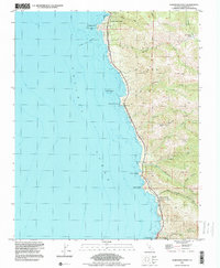
1995 Map of Soberanes Point
USGS Topo · Published 2000About this map
Carmel Highlands marks the northern edge of this coastal survey, where the Santa Lucia Range meets the Pacific Ocean. This 1995 revision of a mid-century survey illustrates the dramatic geography of the Big Sur coast, characterized by numerous drainage canyons like Malpaso Creek, Garrapata Creek, and Palo Colorado Creek that cut through the high ridges. The map captures the interface between land and sea, noting treacherous offshore features like Lobos Rocks and Yankee Point Rock. Cultural markers of the era include the Palo Colorado School and the coastal outpost at Notleys Landing. Large land divisions, including the San Jose Y Sur Chiquito grant, reflect the region's complex history of ranching and land use, while The California Sea Otter Game Refuge highlights early conservation efforts along this shoreline.
Find a feature on this map
32 named features on this map. Tap any name to fly to it.
Don’t see what you’re looking for? This feature index may not catch every label — zoom into the map to look around manually.
Map Details
Editions of this 1995 Soberanes Point Map
This is the sole edition of this map. No revisions or reprints were ever made.
Other maps of this area

1913 · Monterey
USGS Topo · 1:62,500

1918 · Point Sur
USGS Topo · 1:62,500

1925 · Point Sur
USGS Topo · 1:62,500

1941 · Monterey
USGS Topo · 1:62,500

1947 · Point Sur
USGS Topo · 1:62,500

1947 · Seaside
USGS Topo · 1:24,000

1947 · Monterey
USGS Topo · 1:62,500

1947 · Monterey
USGS Topo · 1:24,000

1948 · Santa Cruz
USGS Topo · 1:250,000
1948 · Seaside
USGS Topo · 1:24,000