1948 Map of Seaside
USGS Topo · Published 1948About this map
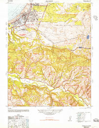
Seaside and its surrounding coastal uplands are captured here during a period of significant military and civic expansion. The northern portion of the map is dominated by the Fort Ord Military Reservation, including the Target Range and Camp Huffman, showing the footprint of World War II-era training grounds. Along the coast of Monterey Bay, the growing street grids of Del Monte Heights and Fort Ord Village contrast with the established grounds of the Hotel Del Monte and its nearby Polo Field.
Find a feature on this map
40 named features on this map. Tap any name to fly to it.
Don’t see what you’re looking for? This feature index may not catch every label — zoom into the map to look around manually.
Map Details
Editions of this 1948 Seaside Map
This is the sole edition of this map. No revisions or reprints were ever made.
Other maps of this area

1910 · Salinas
USGS Topo · 1:31,680

1912 · Salinas
USGS Topo · 1:62,500

1913 · Monterey
USGS Topo · 1:62,500

1918 · Point Sur
USGS Topo · 1:62,500

1920 · Jamesburg
USGS Topo · 1:48,000

1921 · Jamesburg
USGS Topo · 1:62,500

1925 · Point Sur
USGS Topo · 1:62,500

1939 · Jamesburg
USGS Topo · 1:62,500

1940 · Salinas
USGS Topo · 1:62,500

1940 · Jamesburg
USGS Topo · 1:62,500