1983 Map of Seaside
USGS Topo · Published 1985About this map
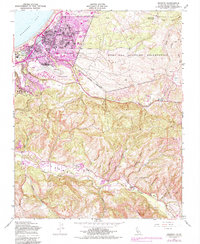
Seaside and its surrounding coastal hills are captured here in a period of significant urban transition, with purple overprint indicating the expansion of residential and commercial zones by the early 1980s. The landscape is dominated by the sprawling Fort Ord Military Reservation to the east and the coastal developments of Del Monte Heights and Noche Buena near the shoreline of Monterey Bay. Transportation and infrastructure are central to the area's character, featuring the Southern Pacific rail line and the Monterey Municipal Airport. To the south, the terrain shifts into the canyons and ridges of the Carmel Valley and Los Laurelles, where the Carmel River winds through more open country. Notable local landmarks like the Laguna Seca Recreation Area and numerous neighborhood schools, such as Martin Luther King Jr High Sch and Ord Terrace Sch, provide specific points of interest for local history and genealogy.
Find a feature on this map
52 named features on this map. Tap any name to fly to it.
Don’t see what you’re looking for? This feature index may not catch every label — zoom into the map to look around manually.
Map Details
Editions of this 1983 Seaside Map
This is the sole edition of this map. No revisions or reprints were ever made.
Other maps of this area

1910 · Salinas
USGS Topo · 1:31,680

1912 · Salinas
USGS Topo · 1:62,500

1913 · Monterey
USGS Topo · 1:62,500

1918 · Point Sur
USGS Topo · 1:62,500

1920 · Jamesburg
USGS Topo · 1:48,000

1921 · Jamesburg
USGS Topo · 1:62,500

1925 · Point Sur
USGS Topo · 1:62,500

1939 · Jamesburg
USGS Topo · 1:62,500

1940 · Salinas
USGS Topo · 1:62,500

1940 · Jamesburg
USGS Topo · 1:62,500