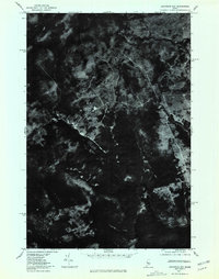
1977 Map of Socatean Bay
USGS Topo · Published 1981About this map
Moosehead Lake dominates the southern reaches of this 1977 orthophotoquad, a specialized document that uses rectified aerial imagery to show the true texture of the Maine woods. The dark waters of Socatean Bay extend into the timberlands of Somerset County, where the landscape is defined by the dense forest cover and a network of logging roads and clearings visible from the air. Further north, the winding course of Williams Brook cuts through the timber, revealing the drainage patterns that feed into the larger lake system. Unlike traditional topographic maps, this imagery-based study provides an unfiltered look at the industrial forest at a moment in time when timber harvesting and shoreline preservation shaped the region's character.
Find a feature on this map
3 named features on this map. Tap any name to fly to it.
Don’t see what you’re looking for? This feature index may not catch every label — zoom into the map to look around manually.
Map Details
Editions of this 1977 Socatean Bay Map
This is the sole edition of this map. No revisions or reprints were ever made.
Other maps of this area

1920 · Moosehead Lake
USGS Topo · 1:62,500

1921 · Brassua Lake
USGS Topo · 1:62,500

1922 · Moosehead Lake
USGS Topo · 1:62,500

1923 · Brassua Lake
USGS Topo · 1:62,500

1930 · Moosehead Lake
USGS Topo · 1:62,500

1944 · Brassua Lake
USGS Topo · 1:62,500

1944 · Moosehead Lake
USGS Topo · 1:62,500

1954 · Seboomook Lake
USGS Topo · 1:62,500

1954 · North East Carry
USGS Topo · 1:62,500

1954 · Millinocket
USGS Topo · 1:250,000
Featured Places
- Tomhegan Township, ME
- West Middlesex Canal Grant Township, ME
- Seboomook Township, ME
- Plymouth Township, ME
- Big W Township, ME