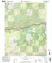
2000 Map of Soda Springs
USGS Topo · Published 2003About this map
The South Yuba River carves through this high Sierra Nevada landscape, tracing a corridor of transit and timber history just west of the summit. In this 2000 revision, the infrastructure of the Tahoe National Forest is on full display, from the industrial Tamarack Substation to the educational grounds of the Donner Trail School. Modern roads like Donner Pass Road parallel the historic path of the Emigrant Trail, illustrating how early pioneer routes dictated the modern transportation network. Scattered settlements and summer camps like Soda Springs, Kingvale, and Camp Pahatsi emphasize the area's dual identity as a mountain getaway and a critical utility corridor. Further south, the map details specialized land management within the Onion Creek Experimental Forest, surrounded by dozens of high-altitude water bodies including Kidd Lake and the Ice Lakes.
Find a feature on this map
50 named features on this map. Tap any name to fly to it.
Don’t see what you’re looking for? This feature index may not catch every label — zoom into the map to look around manually.
Map Details
Editions of this 2000 Soda Springs Map
This is the sole edition of this map. No revisions or reprints were ever made.
Other maps of this area

1891 · Colfax
USGS Topo · 1:125,000

1891 · Truckee
USGS Topo · 1:125,000

1892 · Colfax
USGS Topo · 1:125,000

1893 · Truckee
USGS Topo · 1:125,000

1894 · Colfax
USGS Topo · 1:125,000

1895 · Truckee
USGS Topo · 1:125,000

1898 · Colfax
USGS Topo · 1:125,000

1900 · Colfax
USGS Topo · 1:125,000

1902 · Colfax
USGS Topo · 1:125,000

1932 · Truckee
USGS Topo · 1:96,000