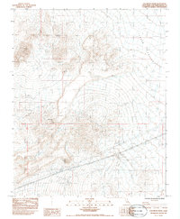
1983 Map of Solomons Knob
USGS Topo · Published 1985About this map
Telegraph Mine and the Wyoming Mine anchor this desert landscape, reflecting the persistent mining activity found in the Mojave region during the late twentieth century. Located near Halloran Summit, these sites are surrounded by a network of drainage systems like Halloran Wash and Bull Spring Wash. The terrain is dominated by the prominent peak of Solomons Knob, while the expansive Shadow Valley stretches across the eastern half of the sheet. Critical desert water sources such as Francis Spring and Bull Spring are meticulously recorded, alongside modern landmarks like a Radio Facility. The map provides a clear look at the arid topography and the industrial footprints left by prospectors and mining operations in this corner of San Bernardino County.
Find a feature on this map
15 named features on this map. Tap any name to fly to it.
Don’t see what you’re looking for? This feature index may not catch every label — zoom into the map to look around manually.
Map Details
Editions of this 1983 Solomons Knob Map
2 editions found
Other maps of this area

1910 · Ivanpah
USGS Topo · 1:250,000

1912 · Ivanpah
USGS Topo · 1:250,000

1942 · Ivanpah
USGS Topo · 1:250,000

1947 · Kingman
USGS Topo · 1:250,000

1948 · Kingman
USGS Topo · 1:250,000

1954 · Kingman
USGS Topo · 1:250,000

1955 · Kingman
USGS Topo · 1:250,000

1955 · Kingston Peak
USGS Topo · 1:62,500

1955 · Mescal Range
USGS Topo · 1:62,500

1956 · Halloran Spring
USGS Topo · 1:62,500