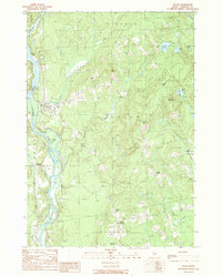
1989 Map of Solon
USGS Topo · Published 1989About this map
The Kennebec River carves through the heart of Somerset County, defining the western border of the town of Solon. This late twentieth-century landscape reveals a mix of riverside industrial infrastructure and traditional agricultural crossroads. At the town center, a Footbridge and the Williams Dam sit near a prominent Power Plant, highlighting the river's utility, while Arnolds Landing marks the shoreline further north. To the east and south, the terrain rises into family-named heights such as Parkman Hill and Eaton Hill. Small rural clusters like South Solon, Twelve Corners, and Rice Corner are distributed across the hills, often anchored by a local Cem, reflecting the deep-seated settlement patterns of the Upper Kennebec Valley before modern development altered the rural character.
Find a feature on this map
33 named features on this map. Tap any name to fly to it.
Don’t see what you’re looking for? This feature index may not catch every label — zoom into the map to look around manually.
Map Details
Editions of this 1989 Solon Map
This is the sole edition of this map. No revisions or reprints were ever made.
Other maps of this area

1903 · Bingham
USGS Topo · 1:62,500

1904 · Anson
USGS Topo · 1:62,500

1905 · Bingham
USGS Topo · 1:62,500

1913 · Skowhegan
USGS Topo · 1:62,500

1948 · Bangor
USGS Topo · 1:250,000

1948 · Kingsbury
USGS Topo · 1:62,500

1950 · Kingsbury
USGS Topo · 1:62,500

1954 · Millinocket
USGS Topo · 1:250,000

1955 · Anson
USGS Topo · 1:62,500

1955 · Skowhegan
USGS Topo · 1:62,500