1953 Map of Somerville
USGS Topo · Published 1954About this map
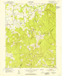
The US Naval Reservation Quantico Marine Base dominates the eastern landscape of this mid-century survey, where the wooded hills of Virginia meet the strategic needs of the post-war military. Beyond the base boundaries, the terrain is defined by a traditional rural network of small settlements and faith centers, including Bristersburg, Somerville, and Sowego. Several congregational landmarks such as Hearts Delight Ch, Mt Horeb Ch, and Calvary Ch are scattered across the Piedmont, often situated near family-named cemeteries like Carver Cem and Cedar Run Cem. The map captures a moment when local landmarks like Tacketts Mill and the Fauquier-Stafford Lookout Tower served as essential navigational and community points. Waterways like Cedar Run, Negro Run, and Aquia Creek wind through the hills, illustrating the natural drainage patterns that have historically shaped the roads and property lines of Fauquier, Stafford, and Prince William Counties.
Find a feature on this map
38 named features on this map. Tap any name to fly to it.
Don’t see what you’re looking for? This feature index may not catch every label — zoom into the map to look around manually.
Map Details
Editions of this 1953 Somerville Map
This is the sole edition of this map. No revisions or reprints were ever made.
Other maps of this area

1887 · Spottsylvania
USGS Topo · 1:125,000

1889 · Fredericksburg
USGS Topo · 1:125,000

1890 · Mt. Vernon
USGS Topo · 1:125,000

1891 · Mt. Vernon
USGS Topo · 1:125,000

1892 · Fredericksburg
USGS Topo · 1:125,000

1892 · Spottsylvania
USGS Topo · 1:125,000

1894 · Warrenton
USGS Topo · 1:125,000

1894 · Fredericksburg
USGS Topo · 1:125,000

1894 · Mt. Vernon
USGS Topo · 1:125,000

1897 · Mt. Vernon
USGS Topo · 1:125,000