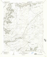
1955 Map of Sonsala Butte 3 NE
USGS Topo · Published 1958About this map
Canyon De Chelly National Monument and the surrounding high desert of the Navajo Indian Reservation are defined here by deep, branching sandstone gorges and ancient archaeological sites. This 1955 survey details a landscape where historical geography is etched into the terrain at places like Massacre Cave Ruins and Mummy Cave Ruins. Situated atop the Defiance Plateau, the area features a complex network of traditional pathways, including the Spanish Trail and Red Clay Trail, which navigate the steep descents into Muerto Canyon and Tseh-ya-kin Canyon. Unlike later maps of more developed regions, this sheet highlights a terrain of isolation and preservation, showing only isolated markers of human modification like small dams, Bear Spring, and the high-altitude Reservoir on the plateau's surface.
Find a feature on this map
34 named features on this map. Tap any name to fly to it.
Don’t see what you’re looking for? This feature index may not catch every label — zoom into the map to look around manually.
Map Details
Editions of this 1955 Sonsala Butte 3 NE Map
This is the sole edition of this map. No revisions or reprints were ever made.
Other maps of this area

1892 · Canyon De Chelly
USGS Topo · 1:250,000

1954 · Shiprock
USGS Topo · 1:250,000

1955 · Sonsala Butte 2 SW
USGS Topo · 1:24,000

1955 · Sonsala Butte 4 NW
USGS Topo · 1:24,000

1955 · Sonsala Butte 3 SE
USGS Topo · 1:24,000

1955 · Sonsala Butte 2 SE
USGS Topo · 1:24,000
1955 · Sonsala Butte 3 SW
USGS Topo · 1:24,000

1955 · Sonsala Butte 1 SW
USGS Topo · 1:24,000
1955 · Sonsala Butte 4 SW
USGS Topo · 1:24,000
1955 · Sonsala Butte 3 NW
USGS Topo · 1:24,000