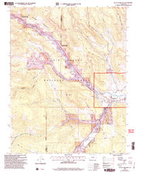
2001 Map of South Fork West
USGS Topo · Published 2005About this map
Rio Grande and its South Fork Rio Grande converge near the town of South Fork, anchoring a landscape shaped by water management and recreational settlement. This 2001 revision of the 1967 topography highlights the critical role of irrigation through the Highline Ditch and the preservation of natural habitat within the Coller State Wildlife Area. The map reveals a cluster of specialized communities, from the seasonal Alamo Summer Homes to the historic Masonic Park and the uniquely named Model T Park. Steep terrain transitions from the Palisades in the north to the rugged canyons of the south, where the Elk Creek Trail and Goodrich Trail offer passage through the Rio Grande National Forest. Researchers will find a detailed view of the junction's development, including the Baxterville site and several ranching outposts like Elk Ranch.
Find a feature on this map
36 named features on this map. Tap any name to fly to it.
Don’t see what you’re looking for? This feature index may not catch every label — zoom into the map to look around manually.
Map Details
Editions of this 2001 South Fork West Map
This is the sole edition of this map. No revisions or reprints were ever made.
Other maps of this area

1914 · Creede
USGS Topo · 1:125,000

1916 · Creede
USGS Topo · 1:125,000

1945 · Durango
USGS Topo · 1:250,000

1953 · Durango
USGS Topo · 1:250,000

1954 · Durango
USGS Topo · 1:250,000

1957 · Spar City
USGS Topo · 1:62,500

1959 · Creede
USGS Topo · 1:62,500

1961 · Durango
USGS Topo · 1:250,000

1963 · Durango
USGS Topo · 1:250,000

1966 · Durango
USGS Topo · 1:250,000