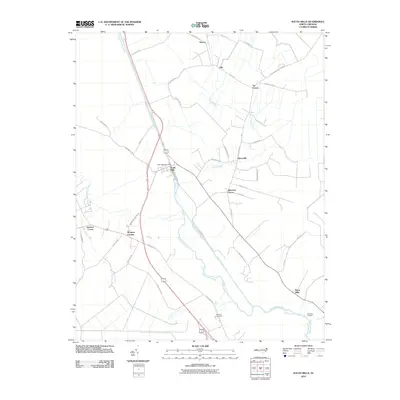
2010 Map of South Mills
USGS Topo · Published 2010About this map
The Dismal Swamp Canal cuts a straight, engineered path through the landscape of Camden County, running alongside the winding Pasquotank River. This area is characterized by a network of rural settlements and family-named intersections that speak to the region's agricultural and maritime history. South Mills serves as a primary hub, featuring the South Mills Post Office and connecting various local roads that navigate the low-lying terrain.
Find a feature on this map
46 named features on this map. Tap any name to fly to it.
Don’t see what you’re looking for? This feature index may not catch every label — zoom into the map to look around manually.
Map Details
Editions of this 2010 South Mills Map
This is the sole edition of this map. No revisions or reprints were ever made.
Other maps of this area

1939 · Moyock
USGS Topo · 1:62,500

1940 · Lake Drummond
USGS Topo · 1:62,500

1940 · South Mills
USGS Topo · 1:62,500

1945 · Lake Drummond
USGS Topo · 1:62,500

1946 · Moyock
USGS Topo · 1:62,500

1948 · Elizabeth City
USGS Topo · 1:62,500

1952 · South Mills
USGS Topo · 1:62,500

1953 · Norfolk
USGS Topo · 1:250,000
1954 · Lake Drummond
USGS Topo · 1:24,000
1954 · Lake Drummond SE
USGS Topo · 1:24,000