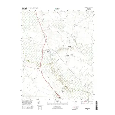
2016 Map of South Mills
USGS Topo · Published 2016About this map
South Mills serves as a central hub at the meeting point of the Dismal Swamp Canal and the upper Pasquotank River in this coastal plain landscape. The terrain is dominated by the eastern edges of the Great Dismal Swamp, where the engineering of the Intracoastal Waterway cuts a straight path through the wetland. The settlement pattern follows the drainage, with crossroads communities like Morgans Corners, Johnsons Corner, and Pierceville established along the periphery of the swamp. To the north, the small hamlets of Sharon and Lilly sit amidst a network of rural roads such as Sharon Church Rd and Pudding Ridge Rd. This area reflects the long-standing reliance on water transport and agriculture in the borderlands between Camden and Pasquotank counties, featuring landmarks like the Memory Gardens cemetery and the localized namesake of Burnt Mills.
Find a feature on this map
67 named features on this map. Tap any name to fly to it.
Don’t see what you’re looking for? This feature index may not catch every label — zoom into the map to look around manually.
Map Details
Editions of this 2016 South Mills Map
This is the sole edition of this map. No revisions or reprints were ever made.
Other maps of this area

1939 · Moyock
USGS Topo · 1:62,500

1940 · Lake Drummond
USGS Topo · 1:62,500

1940 · South Mills
USGS Topo · 1:62,500

1945 · Lake Drummond
USGS Topo · 1:62,500

1946 · Moyock
USGS Topo · 1:62,500

1948 · Elizabeth City
USGS Topo · 1:62,500

1952 · South Mills
USGS Topo · 1:62,500

1953 · Norfolk
USGS Topo · 1:250,000
1954 · Lake Drummond
USGS Topo · 1:24,000
1954 · Lake Drummond SE
USGS Topo · 1:24,000