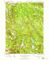
1946 Map of South Sandisfield
USGS Topo · Published 1958About this map
Sandisfield State Forest and the surrounding Berkshire highlands define this 1940s landscape, where small villages are connected by a network of rural routes like Hartford Road and Viets Road. The map documents established settlements including Southfield, Montville, and Sandisfield, alongside the cross-border hamlets of North Norfolk and West Norfolk in Connecticut. These communities are anchored by local landmarks such as the Chapel near the state line and the YMCA Camp on Harmon Pond.
Find a feature on this map
68 named features on this map. Tap any name to fly to it.
Don’t see what you’re looking for? This feature index may not catch every label — zoom into the map to look around manually.
Map Details
Editions of this 1946 South Sandisfield Map
This is the sole edition of this map. No revisions or reprints were ever made.
Other maps of this area

1885 · Sheffield
USGS Topo · 1:62,500

1888 · Sheffield
USGS Topo · 1:62,500

1888 · Sandisfield
USGS Topo · 1:62,500

1891 · Sheffield
USGS Topo · 1:62,500

1892 · Winsted
USGS Topo · 1:62,500

1892 · Cornwall
USGS Topo · 1:62,500

1893 · Sheffield
USGS Topo · 1:62,500

1893 · Cornwall
USGS Topo · 1:62,500

1893 · Sandisfield
USGS Topo · 1:62,500

1897 · Sandisfield
USGS Topo · 1:62,500