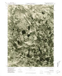
1975 Map of South Sandisfield
USGS Topo · Published 1981About this map
Sandisfield and the neighboring village of Montville sit amidst a heavily wooded landscape of the southern Berkshires as captured in this mid-1970s orthophoto. The imagery reveals the dense forest cover and scattered clearings that define the rural character of New Marlborough and Southfield. Unlike traditional line maps, this photographic survey provides a direct view of the land use patterns and water systems, including the Buck River in the north and the Blackberry River winding through the southern reaches. The cluster at South Sandisfield reflects the persistent, small-scale settlement patterns of this upland region near the Connecticut border. The numerous dark, still bodies of water visible across the terrain indicate a high density of ponds and small lakes, typical of this glaciated geography.
Find a feature on this map
7 named features on this map. Tap any name to fly to it.
Don’t see what you’re looking for? This feature index may not catch every label — zoom into the map to look around manually.
Map Details
Editions of this 1975 South Sandisfield Map
This is the sole edition of this map. No revisions or reprints were ever made.
Other maps of this area

1885 · Sheffield
USGS Topo · 1:62,500

1888 · Sheffield
USGS Topo · 1:62,500

1888 · Sandisfield
USGS Topo · 1:62,500

1891 · Sheffield
USGS Topo · 1:62,500

1892 · Winsted
USGS Topo · 1:62,500

1892 · Cornwall
USGS Topo · 1:62,500

1893 · Sheffield
USGS Topo · 1:62,500

1893 · Cornwall
USGS Topo · 1:62,500

1893 · Sandisfield
USGS Topo · 1:62,500

1897 · Sandisfield
USGS Topo · 1:62,500