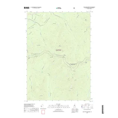
2018 Map of South Twin Mountain
USGS Topo · Published 2018About this map
The White Mountain National Forest dominates this high-altitude landscape in Grafton County, defined by a series of massive granite peaks and the headwaters of the regional river system. The Appalachian National Scenic Trail winds across the major ridges, connecting Mt Garfield to the summits of South Twin Mtn and Mt Guyot. This topography creates a complex drainage pattern where the N Br Gale River and Franconia Brook carve deep valleys through the presidential range foothills. Seasonal recreation is a primary feature of the terrain, indicated by an extensive network of named winter routes such as the Badger Trail XC (Snow) and the Gale River Loop Snomo (Snow). Key landmarks for navigation and conservation include the Littleton Reservoir and the remote Thirteen Falls, illustrating the region's importance as both a watershed and a wilderness destination.
Find a feature on this map
59 named features on this map. Tap any name to fly to it.
Don’t see what you’re looking for? This feature index may not catch every label — zoom into the map to look around manually.
Map Details
Editions of this 2018 South Twin Mountain Map
This is the sole edition of this map. No revisions or reprints were ever made.
Other maps of this area

1893 · Mt. Washington
USGS Topo · 1:62,500

1895 · Crawford Notch
USGS Topo · 1:62,500

1896 · Mt. Washington
USGS Topo · 1:62,500

1896 · Crawford Notch
USGS Topo · 1:62,500

1900 · Whitefield
USGS Topo · 1:62,500

1929 · Franconia
USGS Topo · 1:62,500

1932 · Franconia
USGS Topo · 1:62,500

1935 · Whitefield
USGS Topo · 1:48,000

1935 · Mt. Washington
USGS Topo · 1:62,500
1938 · Mt. Washington
USGS Topo · 1:62,500