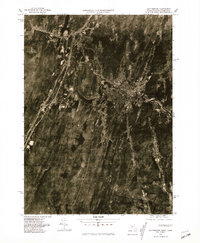
1975 Map of Southbridge
USGS Topo · Published 1981About this map
The Quinebaug River winds through the industrial and residential heart of south-central Massachusetts in this orthophotoquad, which captures the region's mid-1970s development. The dense urban grid of Southbridge occupies the central valley, showing the close relationship between the town’s growth and the river’s path. To the west, the more dispersed settlements of Sturbridge and Fiskdale are visible, alongside the rural intersection of Sherman Corner to the southeast. Unlike traditional line maps, this photographic study reveals the actual texture of the land—from the forested ridges and agricultural clearings to the expanding road network and the cluster of structures at Westville. It provides an authentic view of the Worcester County landscape before further late-century suburbanization altered these historic mill town surroundings.
Find a feature on this map
6 named features on this map. Tap any name to fly to it.
Don’t see what you’re looking for? This feature index may not catch every label — zoom into the map to look around manually.
Map Details
Editions of this 1975 Southbridge Map
This is the sole edition of this map. No revisions or reprints were ever made.
Other maps of this area

1887 · Brookfield
USGS Topo · 1:62,500

1889 · Webster
USGS Topo · 1:62,500

1889 · Putnam
USGS Topo · 1:62,500

1890 · Brookfield
USGS Topo · 1:62,500

1892 · Woodstock
USGS Topo · 1:62,500

1892 · Webster
USGS Topo · 1:62,500

1893 · Putnam
USGS Topo · 1:62,500

1893 · Brookfield
USGS Topo · 1:62,500

1908 · Quinsigamond
USGS Topo · 1:125,000

1908 · Ware
USGS Topo · 1:125,000