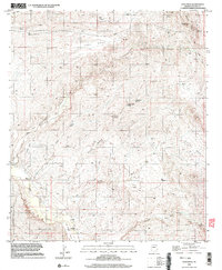
1996 Map of Soza Mesa
USGS Topo · Published 2003About this map
The San Pedro Valley serves as the focal point for this 1996 survey of the high desert corridor in Cochise County. The San Pedro River winds through the southwestern corner, anchoring a landscape where riparian life meets the arid slopes of the Little Dragoon Mountains. Near the small settlement of Cascabel, the map records the Majalca Ranch and a lone Cemetery, marking the long-standing human presence in this river valley. To the north, the terrain rises sharply toward the expansive Soza Mesa, a high plateau dissected by deep drainage systems like Poor Canyon and Hot Springs Canyon. This map captures a transition from the lower river basin to the rugged uplands, where vital water sources such as Hackberry Spring and Sierra Blanca Spring were essential for the cattle ranching and early prospecting efforts signaled by a Prospect in the south. The isolation of the Teran Basin underscores the difficulty of travel through these canyons before modern infrastructure.
Find a feature on this map
23 named features on this map. Tap any name to fly to it.
Don’t see what you’re looking for? This feature index may not catch every label — zoom into the map to look around manually.
Map Details
Editions of this 1996 Soza Mesa Map
This is the sole edition of this map. No revisions or reprints were ever made.
Other maps of this area

1943 · Dragoon
USGS Topo · 1:62,500

1943 · Winchester Mts.
USGS Topo · 1:62,500

1945 · Redington
USGS Topo · 1:62,500

1945 · Winchester Mts.
USGS Topo · 1:62,500

1945 · Happy Valley
USGS Topo · 1:62,500

1956 · Tucson
USGS Topo · 1:250,000

1957 · Redington
USGS Topo · 1:62,500

1957 · Winchester Mts.
USGS Topo · 1:62,500

1958 · Tucson
USGS Topo · 1:250,000

1958 · Happy Valley
USGS Topo · 1:62,500