
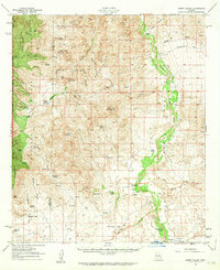
1958 Map of Happy Valley
USGS Topo · Published 1959About this map
The San Pedro River valley defines the eastern reaches of this Cochise County landscape, where the settlement of Pomerene sits near the southern margin. Based on planetable surveys from the 1940s with culture revisions from the late 1950s, the map reveals a rugged ranching economy deeply tied to the terrain and water sources of the Rincon Mountains. Numerous family-held holdings like the Allen Ranch, Pacheco Ranch, and Martinez Ranch are scattered across the foothills and canyons, often situated near vital springs such as Kiper Spring or Bear Spring.
Find a feature on this map
57 named features on this map. Tap any name to fly to it.
Don’t see what you’re looking for? This feature index may not catch every label — zoom into the map to look around manually.
Map Details
Editions of this 1958 Happy Valley Map
2 editions found
Other maps of this area

1904 · Patagonia
USGS Topo · 1:125,000

1904 · Tucson
USGS Topo · 1:125,000

1905 · Patagonia
USGS Topo · 1:125,000

1905 · Tucson
USGS Topo · 1:125,000

1915 · Benson
USGS Topo · 1:125,000

1922 · St. David
USGS Topo · 1:62,500

1926 · Whetstone
USGS Topo · 1:62,500

1943 · Benson
USGS Topo · 1:125,000

1943 · Dragoon
USGS Topo · 1:62,500

1943 · Winchester Mts.
USGS Topo · 1:62,500