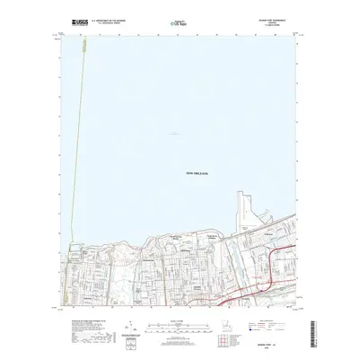
2020 Map of Spanish Fort
USGS Topo · Published 2020About this map
Lake Pontchartrain defines the northern edge of this urban landscape, where the lakefront meets the structured neighborhoods of New Orleans. The map documents a complex network of waterways and reclaimed land, including the Inner Harbor Navigation Canal and several smaller channels like Morrison Canal. This area is characterized by a mix of historic lakefront recreation at Pontchartrain Beach and institutional footprints such as the University of New Orleans and the New Orleans Baptist Theological Seminary. Traces of the city's funerary history are preserved in a cluster of religious cemeteries, including Ahavas Sholem Cem, Beth Israel Cem, and Hebrew Rest Cem. These sites, along with the residential grids of Lakeview and Gentilly, illustrate the dense, water-bound geography of the city's northern districts.
Find a feature on this map
57 named features on this map. Tap any name to fly to it.
Don’t see what you’re looking for? This feature index may not catch every label — zoom into the map to look around manually.
Map Details
Editions of this 2020 Spanish Fort Map
This is the sole edition of this map. No revisions or reprints were ever made.
Other maps of this area

1891 · Spanish Fort
USGS Topo · 1:62,500

1891 · New Orleans
USGS Topo · 1:62,500

1892 · Chef Menteur
USGS Topo · 1:62,500

1892 · St. Bernard
USGS Topo · 1:62,500

1932 · New Orleans NE
USGS Topo · 1:31,680

1932 · New Orleans NW
USGS Topo · 1:31,680

1936 · South Point
USGS Topo · 1:31,680

1936 · Chef Menteur
USGS Topo · 1:62,500

1936 · Spanish Fort
USGS Topo · 1:62,500

1938 · Little Woods
USGS Topo · 1:31,680