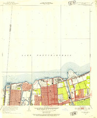
1951 Map of Spanish Fort
USGS Topo · Published 1953About this map
Lake Pontchartrain defines the northern edge of this New Orleans landscape, where mid-century urban expansion meets the water. The lakefront is a hub of institutional and recreational activity, featuring Pontchartrain Beach and the New Orleans Airport jutting into the lake. Inland, the grid of New Orleans is bisected by a network of drainage and transport waterways, including the Inner Harbor Navigation Canal and Bayou St. John. This era of the city's development is marked by significant federal and local infrastructure, such as the Veterans Administration Hospital and the Milne Home For Boys. The map also captures the historic site of Spanish Fort and the small settlement of Demourelles near the southern edge of City Park, providing a look at the residential and civic layout before the extensive interstate developments of later decades.
Find a feature on this map
37 named features on this map. Tap any name to fly to it.
Don’t see what you’re looking for? This feature index may not catch every label — zoom into the map to look around manually.
Map Details
Editions of this 1951 Spanish Fort Map
2 editions found
Other maps of this area

1891 · Spanish Fort
USGS Topo · 1:62,500

1891 · New Orleans
USGS Topo · 1:62,500

1892 · Chef Menteur
USGS Topo · 1:62,500

1892 · St. Bernard
USGS Topo · 1:62,500

1932 · New Orleans NE
USGS Topo · 1:31,680

1932 · New Orleans NW
USGS Topo · 1:31,680

1936 · South Point
USGS Topo · 1:31,680

1936 · Chef Menteur
USGS Topo · 1:62,500

1936 · Spanish Fort
USGS Topo · 1:62,500

1938 · Little Woods
USGS Topo · 1:31,680