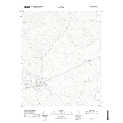
2020 Map of Sparta
USGS Topo · Published 2020About this map
The Hancock County Courthouse serves as the focal point for Sparta, Georgia, where a dense network of streets like W Broad St and Court St radiates into the surrounding agricultural landscape. This survey reveals a community deeply rooted in its local history, evidenced by the numerous burial grounds and religious sites scattered throughout the quadrangle. From the central Sparta Cem to the outlying Smyrna Methodist Church Cem and Saint Mark African Methodist Episcopal Church Cem, these sites offer significant detail for genealogists. The terrain is defined by the headwaters of the Little Ogeechee River and numerous tributaries such as Beaverdam Cr and Fulsome Cr. To the east, the settlement of Culverton sits near the banks of Dry Cr, while landmarks like Coleman Lake and Armstrong Lake dot the landscape between rural homesteads and family cemeteries like the Amos Brantley Family Cem.
Find a feature on this map
102 named features on this map. Tap any name to fly to it.
Don’t see what you’re looking for? This feature index may not catch every label — zoom into the map to look around manually.
Map Details
Editions of this 2020 Sparta Map
This is the sole edition of this map. No revisions or reprints were ever made.
Other maps of this area

1912 · Milledgeville
USGS Topo · 1:62,500

1953 · Athens
USGS Topo · 1:250,000

1958 · Athens
USGS Topo · 1:250,000

1959 · Athens
USGS Topo · 1:250,000

1960 · Warthen NE
USGS Topo · 1:24,000

1961 · Warthen NW
USGS Topo · 1:24,000

1963 · Athens
USGS Topo · 1:250,000

1972 · Shoulderbone
USGS Topo · 1:24,000

1972 · Sparta NW
USGS Topo · 1:24,000
1972 · Jewell
USGS Topo · 1:24,000