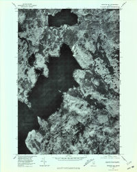
1977 Map of Spencer Bay
USGS Topo · Published 1981About this map
Spencer Bay dominates this orthophoto, reaching deep into the forested interior of Piscataquis County as a major arm of Moosehead Lake. Created from aerial photography taken in late 1977, the imagery reveals the intricate shoreline and dense timberlands characteristic of the North Maine Woods. The landscape is defined by its water systems, where the Roach River enters the bay from the east and Jewett Brook drains the marshy lowlands nearby. To the north, the isolated Spencer Pond is separated from the main bay by a narrow neck of land, while Hardwood Hill provides a distinct topographical rise amidst the surrounding wetlands. This document captures the wilderness state of the region before modern development, recording the exact placement of remote water bodies like Lucky Pond and the network of logging roads that began to penetrate the timber stands.
Find a feature on this map
7 named features on this map. Tap any name to fly to it.
Don’t see what you’re looking for? This feature index may not catch every label — zoom into the map to look around manually.
Map Details
Editions of this 1977 Spencer Bay Map
This is the sole edition of this map. No revisions or reprints were ever made.
Other maps of this area

1920 · Moosehead Lake
USGS Topo · 1:62,500

1922 · Moosehead Lake
USGS Topo · 1:62,500

1930 · Moosehead Lake
USGS Topo · 1:62,500

1944 · Moosehead Lake
USGS Topo · 1:62,500

1952 · First Roach Pond
USGS Topo · 1:62,500

1954 · North East Carry
USGS Topo · 1:62,500

1954 · Grant Farm
USGS Topo · 1:62,500

1954 · Millinocket
USGS Topo · 1:250,000

1957 · Moosehead Lake
USGS Topo · 1:62,500

1958 · Millinocket
USGS Topo · 1:250,000
Featured Places
- Days Academy Grant Township, ME
- Spencer Bay Township, ME
- Lily Bay Township, ME
- East Middlesex Canal Grant Township, ME
- Piscataquis County, ME