2023 Map of Spencer
USGS Topo · Published 2023About this map
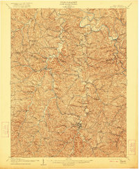
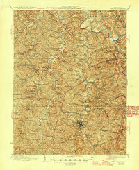
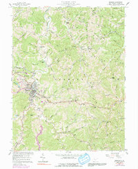
The Roane County Courthouse and Roane County Magistrate Court anchor the seat of local government in Spencer, where the street grid transitions into the complex drainage patterns of the West Virginia hills. The town is flanked by historic sites like College Hill and Spencer Memorial Cem, while the outlying areas of Alvord and Triplett are defined by deep hollows such as Laurel Hollow and Knotts Hollow. The landscape is a network of winding runs, including Spring Creek and Nancy Run, which carve through ridges like Craig Ridge and Mulberry Ridge. For genealogists, the map is particularly dense with small family burial grounds and community cemeteries, from the Depue Cem in the north to the Smith Cem in the southeast. Modern infrastructure is represented by the Slate Run Airport and Boggs Field, illustrating how aviation and recreation have integrated into these traditional valley corridors.
Find a feature on this map
142 named features on this map. Tap any name to fly to it.
Don’t see what you’re looking for? This feature index may not catch every label — zoom into the map to look around manually.
Map Details
Editions of this 2023 Spencer Map
This is the sole edition of this map. No revisions or reprints were ever made.
Historical Maps of Nancy Run Through Time
4 maps found