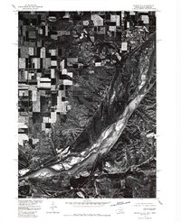
1977 Map of Springfield
USGS Topo · Published 1979About this map
The Missouri River dominates this orthophotograph, winding southeast through a braided channel system defined by broad sandbars and shifting islands. Along the northern bluffs, the settlement of Springfield sits at the edge of the upland plateau, its established grid of streets and buildings contrasting with the complex, organic textures of the river valley below. Produced in cooperation with the Bureau of Indian Affairs, this 1977 aerial survey captures the distinct transition between the high, rectangular agricultural fields of South Dakota and the rugged, uncultivated drainages that drop toward the water. The imagery provides a clear view of the mid-century shoreline and the intricate network of farm roads and land divisions that define the rural landscape surrounding the town.
Find a feature on this map
2 named features on this map. Tap any name to fly to it.
Don’t see what you’re looking for? This feature index may not catch every label — zoom into the map to look around manually.
Map Details
Editions of this 1977 Springfield Map
This is the sole edition of this map. No revisions or reprints were ever made.
Other maps of this area

1950 · Niobrara
USGS Topo · 1:24,000

1950 · Verdigre NE
USGS Topo · 1:24,000

1955 · Sioux City
USGS Topo · 1:250,000

1955 · O'Neill
USGS Topo · 1:250,000

1958 · Sioux City
USGS Topo · 1:250,000

1959 · O'Neill
USGS Topo · 1:250,000

1959 · Sioux City
USGS Topo · 1:250,000

1969 · O'Neill
USGS Topo · 1:250,000

1974 · Sparta
USGS Topo · 1:24,000

1974 · Howe Creek
USGS Topo · 1:24,000
Featured Places
- Springfield, SD
- Hancock Township, SD
- Springfield Township, SD
- Running Water, SD
- Running Water Township, SD