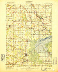
1917 Map of St. Charles
USGS Topo · Published 1917About this map
St Charles serves as the focal point of this Saginaw County landscape, where the confluence of the Bad River and the Shiawassee River anchors the local geography. The map reveals an intensive drainage and irrigation network essential for agriculture, particularly evident in the Prairie Farm and its associated Pumping Station. Industrial activity is represented by No 3 Mine near the village, highlighting the era's reliance on local coal resources.
Find a feature on this map
109 named features on this map. Tap any name to fly to it.
Don’t see what you’re looking for? This feature index may not catch every label — zoom into the map to look around manually.
Map Details
Editions of this 1917 St. Charles Map
4 editions found
Other maps of this area

1916 · Bay City
USGS Topo · 1:62,500

1917 · Chesaning
USGS Topo · 1:62,500

1917 · St. Charles
USGS Topo · 1:62,500

1918 · Elsie
USGS Topo · 1:62,500

1919 · Bay City
USGS Topo · 1:62,500

1919 · Saginaw
USGS Topo · 1:62,500

1919 · Burt
USGS Topo · 1:62,500

1921 · Burt
USGS Topo · 1:62,500

1934 · Sanford
USGS Topo · 1:62,500

1934 · Merrill
USGS Topo · 1:62,500