1942 Map of St. George Island
USGS Topo · Published 1961About this map
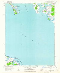
St George Island and the surrounding neck lands of Maryland and Virginia anchor this 1942 survey of the lower Potomac. The landscape is defined by its deep indentation, where the St Marys River meets the Potomac River amidst a complex network of creeks and sounds. Small coastal settlements such as St George Island Beach, Wynne, and Potomac View dot the shorelines, while the Virginia side features the village of Lewisetta near Cherry Point Neck. This map reveals a maritime-dependent geography of the early 1940s, documenting numerous family-named points like Kitts Point, Smith Point, and Travis Point that governed local navigation. The abundance of named inlets, including Island Creek, Smith Creek, and Judith Sound, illustrates the region's historical reliance on water transport before the extensive development of modern inland infrastructure.
Find a feature on this map
39 named features on this map. Tap any name to fly to it.
Don’t see what you’re looking for? This feature index may not catch every label — zoom into the map to look around manually.
Map Details
Editions of this 1942 St. George Island Map
This is the sole edition of this map. No revisions or reprints were ever made.
Other maps of this area

1892 · Piney Point
USGS Topo · 1:62,500

1894 · Piney Point
USGS Topo · 1:62,500

1894 · Point Lookout
USGS Topo · 1:62,500

1895 · Nomini
USGS Topo · 1:125,000

1895 · Piney Point
USGS Topo · 1:62,500

1898 · Nomini
USGS Topo · 1:125,000

1898 · St. Marys
USGS Topo · 1:125,000

1901 · Piney Point
USGS Topo · 1:62,500

1906 · St. Marys
USGS Topo · 1:125,000
1912 · Point Lookout
USGS Topo · 1:62,500