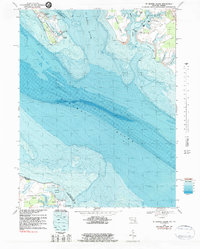
1968 Map of St. George Island
USGS Topo · Published 1983About this map
St George Island and the surrounding Chesapeake Bay inlets are depicted here at the intersection of Maryland and Virginia maritime history. This hydrographic and topographic study illustrates the intricate shoreline where the Potomac River meets the St Marys River, revealing a landscape defined by expansive necks of land like St Inigoes Neck and Cherry Point Neck. The map provides significant detail for those tracing coastal livelihoods, showing small settlements like Wynne and Lewisetta alongside commercial and recreational landmarks such as Clayton Marina and Camp Merryelande.
Find a feature on this map
40 named features on this map. Tap any name to fly to it.
Don’t see what you’re looking for? This feature index may not catch every label — zoom into the map to look around manually.
Map Details
Editions of this 1968 St. George Island Map
3 editions found
Other maps of this area

1892 · Piney Point
USGS Topo · 1:62,500

1894 · Piney Point
USGS Topo · 1:62,500

1894 · Point Lookout
USGS Topo · 1:62,500

1895 · Nomini
USGS Topo · 1:125,000

1895 · Piney Point
USGS Topo · 1:62,500

1898 · Nomini
USGS Topo · 1:125,000

1898 · St. Marys
USGS Topo · 1:125,000

1901 · Piney Point
USGS Topo · 1:62,500

1906 · St. Marys
USGS Topo · 1:125,000

1912 · Point Lookout
USGS Topo · 1:62,500