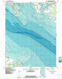
1987 Map of St. George Island
USGS Topo · Published 1987About this map
The St Marys River and Potomac River converge in this detailed mid-1980s bathymetric and topographic survey of the Maryland-Virginia border. St George Island sits as a narrow landform along the western shore, home to St Francis Xavier Ch and the shoreline area of St George Island Beach. The map highlights the maritime character of St. Mary's County, showing the intricate finger-like extensions of Jutland Neck and Tick Neck divided by Jutland Creek and Smith Creek. Across the wide expanse of the Potomac River, the Virginia shoreline at Cherry Point Neck and the settlement of Lewisetta are visible, marking the transition between the two states. The inclusion of the Landing Strip near Wynne and Camp Merryelande reflects the area's development as a coastal retreat and local aviation point during this era.
Find a feature on this map
42 named features on this map. Tap any name to fly to it.
Don’t see what you’re looking for? This feature index may not catch every label — zoom into the map to look around manually.
Map Details
Editions of this 1987 St. George Island Map
This is the sole edition of this map. No revisions or reprints were ever made.
Other maps of this area

1892 · Piney Point
USGS Topo · 1:62,500

1894 · Piney Point
USGS Topo · 1:62,500

1894 · Point Lookout
USGS Topo · 1:62,500

1895 · Nomini
USGS Topo · 1:125,000

1895 · Piney Point
USGS Topo · 1:62,500

1898 · Nomini
USGS Topo · 1:125,000

1898 · St. Marys
USGS Topo · 1:125,000

1901 · Piney Point
USGS Topo · 1:62,500

1906 · St. Marys
USGS Topo · 1:125,000

1912 · Point Lookout
USGS Topo · 1:62,500