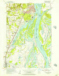
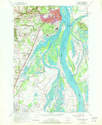
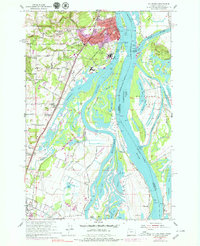
1954 Map of St. Helens
USGS Topo · Published 1957About this map
The Columbia River and its intricate network of sloughs and islands dominate this mid-century landscape along the Oregon-Washington border. At St Helens, the river geography transitions from the open waters of Scappoose Bay to a complex system of navigation ranges, including the St Helens Range and Warrior Rock Range. On the Washington side, Bachelor Island is a mosaic of seasonal lakes such as Canvasback Lake and Widgeon Lake, separated from the mainland by the Bachelor Island Slough.
Find a feature on this map
90 named features on this map. Tap any name to fly to it.
Don’t see what you’re looking for? This feature index may not catch every label — zoom into the map to look around manually.
Map Details
Editions of this 1954 St. Helens Map
Other maps of this area

1897 · Portland
USGS Topo · 1:62,500

1905 · Portland
USGS Topo · 1:62,500

1915 · Hillsboro
USGS Topo · 1:62,500

1918 · Hillsboro
USGS Topo · 1:62,500

1922 · St. Helens
USGS Topo · 1:62,500

1940 · Hillsboro
USGS Topo · 1:62,500

1940 · Portland
USGS Topo · 1:62,500

1940 · La Center
USGS Topo · 1:62,500

1941 · St Helens
USGS Topo · 1:62,500

1943 · St Helens
USGS Topo · 1:62,500