
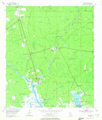
1954 Map of St. Marks
USGS Topo · Published 1956About this map
St Marks sits at the strategic confluence of the Wakulla River and the St Marks River, a site of maritime and military importance anchored by the Site of Old Fort St Marks. By the mid-1950s, this coastal landscape reveals a mix of industrial infrastructure, such as the Oil Tanks near the riverfront, and the vast conservation lands of the St Marks National Wildlife Refuge. The map details the transition from riverine commerce to rail transport, following the Seaboard Air Line down to Newport Station and the settlement of Wakulla. Inland, the terrain is defined by unique hydrologic features like Patterson Sink and Blue Sink, alongside several family cemeteries including Stewart Cem and Cates Cem. The presence of the Purchase Line and numerous private land boundaries reflects the complex property history of the Forbes Purchase area, while remote outposts like Port Leon stand as quiet markers along the coastal marshes.
Find a feature on this map
45 named features on this map. Tap any name to fly to it.
Don’t see what you’re looking for? This feature index may not catch every label — zoom into the map to look around manually.
Map Details
Editions of this 1954 St. Marks Map
2 editions found
Other maps of this area

1940 · Tallahassee
USGS Topo · 1:62,500

1940 · Arran
USGS Topo · 1:62,500

1942 · Tallahassee
USGS Topo · 1:62,500

1943 · Arran
USGS Topo · 1:62,500

1943 · Tallahassee
USGS Topo · 1:62,500

1954 · Sprague Island
USGS Topo · 1:24,000

1954 · Cody
USGS Topo · 1:24,000

1954 · Woodville
USGS Topo · 1:24,000

1954 · St. Marks NE
USGS Topo · 1:24,000

1954 · Cobb Rocks
USGS Topo · 1:24,000