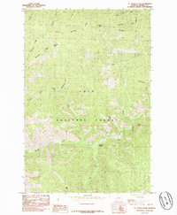
1985 Map of St Patrick Peak
USGS Topo · Published 1985About this map
Lolo National Forest encompasses the high-altitude terrain of this Mineral County landscape, where the drainage of North Fork Fish Creek and West Fork Fish Creek meet. The geography is defined by prominent elevations including St Patrick Peak and Cedar Peak, separated by a complex network of steep gulches and creek beds. A significant waypoint on the landscape is Clearwater Crossing, which serves as a junction for movement through the drainage systems of Packers Gulch and the surrounding peaks. The naming conventions throughout the area, from Heineman Ridge to Mc Ginty Creek, reflect the legacy of early prospecting and timber interests in the Northern Rockies. This provisional survey captures the intricate water system including Tanglefoot Creek and Louisiana Gulch as it existed in the mid-1980s.
Find a feature on this map
22 named features on this map. Tap any name to fly to it.
Don’t see what you’re looking for? This feature index may not catch every label — zoom into the map to look around manually.
Map Details
Editions of this 1985 St Patrick Peak Map
This is the sole edition of this map. No revisions or reprints were ever made.
Other maps of this area

1911 · Lolo
USGS Topo · 1:250,000

1913 · Lolo
USGS Topo · 1:250,000

1956 · Wallace
USGS Topo · 1:250,000

1956 · Hamilton
USGS Topo · 1:250,000

1959 · Hamilton
USGS Topo · 1:250,000

1959 · Tarkio
USGS Topo · 1:62,500

1960 · Wallace
USGS Topo · 1:250,000

1960 · Hamilton
USGS Topo · 1:250,000

1960 · Superior
USGS Topo · 1:62,500

1960 · Straight Peak
USGS Topo · 1:62,500