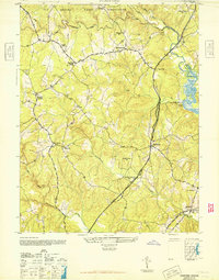
1946 Map of Stafford
USGS Topo · Published 1946About this map
Stafford sits at the heart of this post-war landscape, serving as a hub where the Jefferson Davis Highway meets local routes like the Stafford Parkway. The map reveals a community defined by its crossroads and rural institutions, from the Stafford Training Sch to numerous historic congregations such as Aquia Ch, Ebenezer Ch, and Old Andrew Ch. The northern reaches are dominated by the U S Marine Corps Reservation, indicating the significant military footprint in the region during the 1940s.
Find a feature on this map
28 named features on this map. Tap any name to fly to it.
Don’t see what you’re looking for? This feature index may not catch every label — zoom into the map to look around manually.
Map Details
Editions of this 1946 Stafford Map
This is the sole edition of this map. No revisions or reprints were ever made.
Other maps of this area

1887 · Spottsylvania
USGS Topo · 1:125,000

1889 · Fredericksburg
USGS Topo · 1:125,000

1890 · Mt. Vernon
USGS Topo · 1:125,000

1891 · Mt. Vernon
USGS Topo · 1:125,000

1892 · Fredericksburg
USGS Topo · 1:125,000

1892 · Spottsylvania
USGS Topo · 1:125,000

1894 · Warrenton
USGS Topo · 1:125,000

1894 · Fredericksburg
USGS Topo · 1:125,000

1894 · Mt. Vernon
USGS Topo · 1:125,000

1897 · Mt. Vernon
USGS Topo · 1:125,000