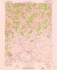
1953 Map of Stamping Ground
USGS Topo · Published 1973About this map
Stamping Ground sits at a nexus of early Kentucky roads where the Locust Fork and McConnell Run converge, reflecting a mid-century landscape of agricultural crossroads and dispersed rural hamlets. The terrain is defined by the winding course of Lecomptes Run and the southern sweep of North and Elkhorn Creek. Genealogists will find a high concentration of family-named landmarks and burial sites, including the Masonic Cem near the town center and the Minorsville Cem to the north. Distinct communities such as Skinnersburg, Minorsville, and Harmony are documented here, often centered around local institutions like Caesarea Ch and Corinth Ch. This 1950s survey documents the traditional settlement patterns of the Scott County hill country before modern infrastructure altered the rural character of these small upland communities.
Find a feature on this map
34 named features on this map. Tap any name to fly to it.
Don’t see what you’re looking for? This feature index may not catch every label — zoom into the map to look around manually.
Map Details
Editions of this 1953 Stamping Ground Map
Other maps of this area

1906 · Lockport
USGS Topo · 1:48,000

1906 · Georgetown
USGS Topo · 1:62,500

1908 · Lockport
USGS Topo · 1:62,500

1908 · Georgetown
USGS Topo · 1:62,500

1922 · Frankfort
USGS Topo · 1:48,000

1924 · Frankfort
USGS Topo · 1:62,500

1939 · Sadieville
USGS Topo · 1:62,500

1952 · Midway
USGS Topo · 1:24,000

1953 · Monterey
USGS Topo · 1:24,000

1953 · Sadieville
USGS Topo · 1:24,000