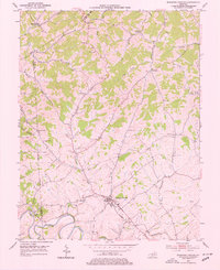
1953 Map of Stamping Ground
USGS Topo · Published 1977About this map
Stamping Ground sits at the heart of this early 1950s landscape, serving as a hub for a rural Kentucky network defined by winding watercourses and small family settlements. The community is tied to the broader region by the Frankfort and Cincinnati railroad and road, which cut through the southern portion of the quadrangle near the North Elkhorn Creek loop. This era shows a densely settled countryside with numerous named points of interest for genealogists, including Minorsville, Skinnersburg, and Suterville.
Find a feature on this map
36 named features on this map. Tap any name to fly to it.
Don’t see what you’re looking for? This feature index may not catch every label — zoom into the map to look around manually.
Map Details
Editions of this 1953 Stamping Ground Map
Other maps of this area

1906 · Lockport
USGS Topo · 1:48,000

1906 · Georgetown
USGS Topo · 1:62,500

1908 · Lockport
USGS Topo · 1:62,500

1908 · Georgetown
USGS Topo · 1:62,500

1922 · Frankfort
USGS Topo · 1:48,000

1924 · Frankfort
USGS Topo · 1:62,500

1939 · Sadieville
USGS Topo · 1:62,500

1952 · Midway
USGS Topo · 1:24,000

1953 · Monterey
USGS Topo · 1:24,000

1953 · Sadieville
USGS Topo · 1:24,000