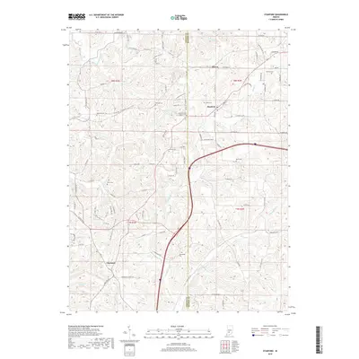
2019 Map of Stanford
USGS Topo · Published 2019About this map
Cincinnati and Stanford anchor this landscape along the border of Greene and Monroe counties, where the topography is defined by the winding paths of Indian Creek and Little Indian Creek. The area is notably dense with small family and community burial grounds, such as Carmichael Cem and Gardner Cem, reflecting generations of settlement in the wooded uplands. Modern infrastructure is represented by the path of 69 cutting through the center, contrasting with the established rural road network that follows the natural contours of the land.
Find a feature on this map
103 named features on this map. Tap any name to fly to it.
Don’t see what you’re looking for? This feature index may not catch every label — zoom into the map to look around manually.
Map Details
Editions of this 2019 Stanford Map
This is the sole edition of this map. No revisions or reprints were ever made.
Other maps of this area

1908 · Bloomington
USGS Topo · 1:48,000

1908 · Bloomfield
USGS Topo · 1:62,500

1910 · Bloomington
USGS Topo · 1:62,500

1935 · Oolitic
USGS Topo · 1:48,000

1942 · Oolitic
USGS Topo · 1:62,500

1953 · Indianapolis
USGS Topo · 1:250,000

1956 · Indianapolis
USGS Topo · 1:250,000
1956 · Clear Creek
USGS Topo · 1:24,000

1956 · Freedom
USGS Topo · 1:24,000
1956 · Bloomington
USGS Topo · 1:24,000