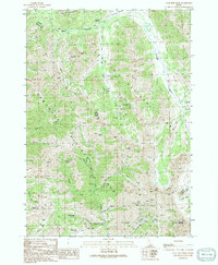
1991 Map of Star Hope Mine
USGS Topo · Published 1991About this map
Mining operations and remote pack trails define this high-altitude landscape where the Challis National Forest and Sawtooth National Forest converge. The terrain is dominated by the White Mountains and the expansive Copper Basin, where geological prospects drew 20th-century exploration. Notable workings include the Star Hope Mine in the northern gulch and the Eagle Bird Mine Adits Shafts further south near Garfield Canyon. This 1991 provisional survey documents the complex network of drainages such as Star Hope Creek and Muldoon Creek that carved the canyons used by early prospectors. Scattered prospects and adits are recorded across the slopes of Glide Mountain and Scorpion Mountain, marking a legacy of mineral extraction that persisted well into the modern era.
Find a feature on this map
43 named features on this map. Tap any name to fly to it.
Don’t see what you’re looking for? This feature index may not catch every label — zoom into the map to look around manually.
Map Details
Editions of this 1991 Star Hope Mine Map
This is the sole edition of this map. No revisions or reprints were ever made.
Other maps of this area

1895 · Hailey
USGS Topo · 1:125,000

1897 · Hailey
USGS Topo · 1:125,000

1935 · MacKay
USGS Topo · 1:96,000

1955 · Idaho Falls
USGS Topo · 1:250,000

1955 · Hailey
USGS Topo · 1:250,000

1958 · Idaho Falls
USGS Topo · 1:250,000

1959 · Hailey
USGS Topo · 1:250,000

1960 · Muldoon Canyon
USGS Topo · 1:62,500

1960 · Copper Basin
USGS Topo · 1:62,500

1962 · Hailey
USGS Topo · 1:250,000