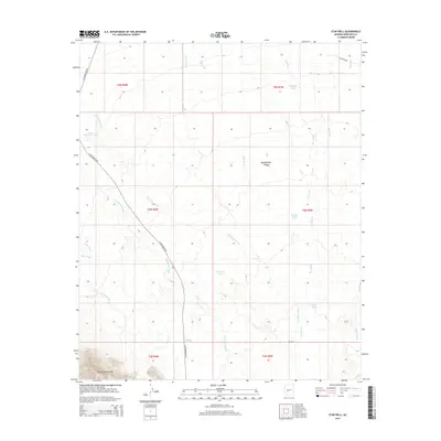
2014 Map of Star Well
USGS Topo · Published 2014About this map
The Belmont Mountains anchor the southern edge of this arid landscape, giving way to the broad expanse of the Hassayampa Plain. Water, a critical resource in this desert environment, is meticulously recorded through a series of cattle tanks and natural drainage systems. Significant catchments such as Mitchell Tank, Mesquite Tank, and Hidden Tank are scattered throughout the territory, while seasonal waterways like Jackrabbit Wash, Mill Wash, and Star Wash define the local topography. This area is traversed by vital desert thoroughfares including N Wickenburg Rd and S Vulture Mine Rd, which likely supported local ranching and mining travel. The presence of Star Well and various powerline structures indicates a landscape managed for infrastructure and livestock in the early 21st century.
Find a feature on this map
29 named features on this map. Tap any name to fly to it.
Don’t see what you’re looking for? This feature index may not catch every label — zoom into the map to look around manually.
Map Details
Editions of this 2014 Star Well Map
This is the sole edition of this map. No revisions or reprints were ever made.
Other maps of this area

1954 · Phoenix
USGS Topo · 1:250,000

1957 · Phoenix
USGS Topo · 1:250,000

1957 · White Tank Mts.
USGS Topo · 1:62,500

1958 · Phoenix
USGS Topo · 1:250,000

1960 · Phoenix
USGS Topo · 1:250,000

1961 · Vulture Mountains
USGS Topo · 1:62,500

1962 · Belmont Mts
USGS Topo · 1:62,500
1965 · Wickenburg SW
USGS Topo · 1:24,000

1969 · Phoenix
USGS Topo · 1:250,000
1971 · Phoenix
USGS Topo · 1:250,000