
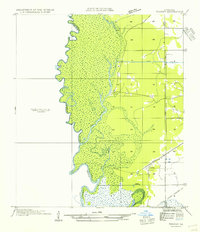
1947 Map of Starks
USGS Topo · Published 1947About this map
The Sabine River forms the serpentine border between Louisiana and Texas in this coastal plain landscape, defining a region where river transport and timber harvesting converge. The settlement of Starks serves as a central hub, situated at the junction of the Kansas City Southern and several regional roads like State Highway No. 7. To the west, the river's floodplains are marked by complex water features such as Patterson Slough, Wildcat Slough, and Stevenson Lake, which underscore the swampy nature of the terrain. The presence of numerous Old Logging Railroad Grades throughout the area highlights the historical importance of the timber industry, while smaller communities like Cupples and Deweyville—the latter featuring a Ferry crossing—anchor the local rural economy. Cultural landmarks like Old Field Ch and Fountain Cem provide essential data points for those researching local family histories and early parish settlements.
Find a feature on this map
26 named features on this map. Tap any name to fly to it.
Don’t see what you’re looking for? This feature index may not catch every label — zoom into the map to look around manually.
Map Details
Editions of this 1947 Starks Map
This is the sole edition of this map. No revisions or reprints were ever made.
Other maps of this area

1926 · Mauriceville
USGS Topo · 1:24,000

1932 · Orange
USGS Topo · 1:62,500

1943 · Mauriceville
USGS Topo · 1:24,000

1947 · Vinton
USGS Topo · 1:31,680

1947 · Toomey
USGS Topo · 1:31,680

1947 · Carter Creek
USGS Topo · 1:31,680

1947 · Lunita
USGS Topo · 1:31,680

1947 · Long Marsh
USGS Topo · 1:31,680

1952 · Lake Charles
USGS Topo · 1:250,000
1954 · Toomey
USGS Topo · 1:31,680